 New York City seems seriously intent on going solar as we wrote in a previous blog post.
One of the possibilities to generate solar power in New York is using the city’s rooftops.
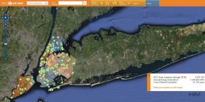
In order to gauge how much space there is, a website called NY Solar Map has been designed to estimate rooftop solar potential using a computer model that calculates the incoming direct and diffuse solar radiation for every square meter of the City of New York.
According to information on the website, the model is based on the position of the sun, overall atmospheric conditions, latitude and shading, which it says is the most important element in the analysis.
Shading is generated from a digital surface model derived from light detection and ranging (called LIDAR data), which captures the surface elevation of the ground, buildings and trees.
Usable roof area within each rooftop is estimated based on slope, roughness, available sunlight, and building shape. When the system estimates the solar potential of an arbitrary polygon, the total area within the polygon is treated as usable. The effects of azimuth and tilt angle are estimated using the PVWatts solar model from the National Renewable Energy Laboratory (NREL).
The project assumes that in order to be usable, rooftop area needs to contain at least 10 contiguous square meters of uninterrupted surface area, either flat or with a uniform slope, and receive at least 1,030kWh of incident solar radiation in a year per square meter. There are several other assumptions explained in further detail on the website.
NY Solar Map is interactive and anyone can add their system to it through a form. There’s also a search engine whereby visitors can find specific addresses to estimate the solar potential of the building. They can also draw a system and calculate the financial payback of installing solar power.
You should follow us here.


1 Comment